Bilaspur
Himachal Pradesh
Bilaspur was the capital of a state of the same name founded in the 7th century, also known as Kahlur. The ruling dynasty were Chandela Rajputs, who claimed descent from the rulers of Chanderi in present-day Madhya Pradesh. The town of Bilaspur was founded in 1663. The state later became a princely state of British India, and was under the authority of the British province of Punjab.
On 13 May 1665, Guru Tegh Bahadur went to Bilaspur to attend the mourning and funeral ceremonies for Raja Dip Chand of Bilaspur. Rani Champa of Bilaspur made an offer to the Guru of a piece of land in her state, which the Guru accepted at the cost of 500 rupees. The land consisted of the villages of Lodhipur, Mianpur, and Sahota. Guru Tegh Bahadur broke ground on a new settlement on 19 June 1665, which he named Nanaki after his mother.
In 1932, the state became part of the newly created Punjab States Agency, and in 1936 the Punjab Hill States Agency was separated from the Punjab States Agency. On 12 October 1948 the local ruler, HH Raja Sir Anand Chand, acceded to the Government of India.
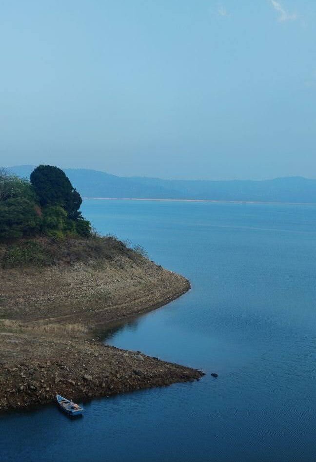
Bilaspur became a separate state of India under a chief commissioner, and on 1 July 1954, Bilaspur State was made a district of Himachal Pradesh state by an act of the Indian Parliament. When the Sutlej River was dammed to create the Govind Sagar, the historic town of Bilaspur was submerged, and a new town was built upslope of the old.
History
Pre Independence
The erstwhile ruling family of Bilaspur claims its descent from Chanderwanshi Rajputs who reigned at Chanderi in the Bundelkhad region of Madhya Pradesh. The place now forms part of Guna district. It is said that the seventh ruler of Chanderi Kingdo m Harihar Chand had a dream of Goddess Jawalamukhi. Thereafter, he decided to seek his fortune in a shrine. As a result of this, he handed over the kingdom to his youngest son Govind and then proceeded towards Jawalamukhi along with his remaining four sons and established themselves at Jindbari where they constructed a fort and settled there for some time before proceeding to Jawalamukhi. They paid a visit to Nadaun the then capital of Kangra. The Raja of Kangra arranged a tent pegging contest and promised his daughter to the men who succeeds in taking a certain peg. In reality this peg was the trunk of a tree, entered the fray. Sabir Chand lost the control of his horse and was killed and the deception practiced by the Kangra Raja was discovered. Thereafter the battle ensued and the Kangra forces were defeated. Kangra Tikka and the Chanderi King Hari Chand were both among the slain.
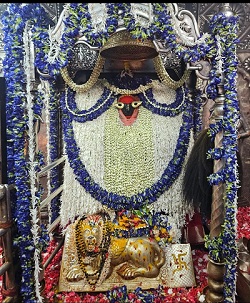
The remaining three Chanderi princes retired to the Jawalamukhi shrine. The reigning Goddess appeared and promised each of them a kingdom. In the fulfillment of her prophecy one of the three princes was adopted by the Raja of Kumaon and other prince Gambhir Chand took possession of Chamba and the eldest son Bir Chand got Jindbari at present in tehsil Anandpur Sahib in Rupnagar district of Punjab. It was Bir Chand who constructed the Naina Devi temple. He extended the Jurisdiction of his kingdom Kahlur during his 33 years of rule and subjugated about 15 neighboring princely states. His ambition of extending jurisdiction was ultimately halted by the Raja of Sirmaur with whom he concluded treaty of peace. Thus, he carved out a kingdom of Kahlur for himself. Bir Chand was followed by a number of his successors and last of them was Kahan Chand who conquered the Hindur state (Nalagarh) and gave it to his second son Surjeet Chand from whom the present ruling family of Nalagarh descends.
The Capital of ruling dynasty continued to be located at Kotkahlur till 1600 A.D. when the heir apparent Bir Chand fled to Sunhani across the river Satluj along with mother where he settled. His father,the then ruler, Gyan Chand embraced Islam at the behest of Mughal ruler at Sirhand who was so impressed with his fine appearance that he gave his own daughter in marriage. He returned to Kotkahlur after conversion. After the death of Raja Gayn Chand, Bir Chand returned to Kotkaklur and got himself installed as the King. He kept his capital at Sunhani on the right side of river Satluj. In 1650 A.D. when Deep Chand of the same dynasty succeeded as Raja of Kahlur state, he decided to shift his capital as he developed strong disliking for the place. It is generally said that accompanied by 2 Hindus and 2 Mohammdan faquirs he sought new site for the capital and finally settled at a place on the left bank of Satluj river traditionally called “Beas gufa” after the name of Rishi Vyas. He built a palace called ‘Dholar’ over looking the river and founded a town on the river bank which was named after Beas gufa and was later on called Bilaspur. Since then the capital of Bilaspur continued to be at Bilaspur though the original town which was established by the Chandel dynasty was submerged in the ’Govind Sagar’ on 1st July, 1954. A new township above the old one has come up at an elevation of 673 metres above sea level.
Post Independence
Himachal Pradesh came into being as a part ‘C’ State of the Indian Union on 15th April, 1948 as result of merger of 30 Punjab and Shimla Hill State in the Indian Union viz. Baghat, Bhajji, Baghal, Beja, Balson, Koti, Kumarsain, Kunihar, Kuthar, Mandi, Bushahr, Chamba, Darkoti, Delath, Dhadi, Dhami, Ghund, Jubbal, Khaneti, Keonthl, Madhan, Mahlog, Mangal, Ratesh, Rawringarh, Sangri, Sirmaur, Suket,Tharoach, Theog. At that time the state had 4 districts viz. Chamba, Mahasu, Mandi, Sirmaur and its area was 2,716,850 hectares. The State was taken over under the Central administration on the12th October, 1948.By an act of Parliament the 31st state of Bilaspur which was till then a separate entity under the control of Chief Commissioner, was integrated with Himachal Pradesh on 1st July, 1954 thereby adding one more district with an area of 106,848 hectares.
Initially, it consisted of two tehsils namely, Ghumarwin and Bilaspur Sadar. In January, 1980 the state government created a separate sub-tehsil called Naina Devi with headquarters at Swarghat out of Bilaspur Sadar Tehsil. In 1984 one new sub-tehsil namely, Jhandutta was created by carving out some areas of tehsil Ghumarwin. Jhandutta sub-tehsil was given full tehsil status in January, 1998. Administratively, the district is divided into two sub-divisions, 3 tehsils, 1 sub-tehsil, 3 community development blocks, 136 panchayats, 2 municipal committees and 2 notified area committees.
Bilaspur had been a town in 1891 and 1901 Censuses but was declassified thereafter in the year 1911. In 1931 Census, it was again classified as town and has been continuing as such since then. Naina Devi a place of religious importance was declared as town for the first time in 1953. A small town committee was setup to look after the affairs of this place till 1960. In the year 1961 it was notified as municipal committee. After 1981 Census, one more place Shah Talai has been classified as notified area committee.
How to Reach
Buses are the only mode of public transport to the district and run from all major towns within the state as well as from those outside it. Bilaspur lies on the NH-205 highway which is Chandigarh Manali Highway. It is 86 km away from Shimla, the state capital, and 405 km from Delhi. The nearest airports with daily scheduled flights are from Bhunter in Kullu District and Gaggal in Kanga District. Manali, a major tourist attraction in Himachal Pradesh, is located 195 km from Bilaspur. Mandi, 70 km away, contains the Zonal headquarters of the district. Most of the long route buses that service Bilaspur are run by the state owned HRTC; local routes are operated by private bus operators.